
LiDAR Drone Market Share, Size, Trends, Industry Analysis Report, By Type (Fixed-Wing, Rotary-Wing); By Range (Short Range, Medium Range, Long Range); By Component (Cameras, Navigation and Positioning Units, Laser Scanners, Others); By Application (Corridor Mapping, Aerospace and Defense, Mining, Construction, Entertainment, Environment, Agriculture, Others); By Regions; Segment Forecast, 2020 - 2026
- Published Date:Jun-2020
- Pages: 101
- Format: PDF
- Report ID: PM1678
- Base Year: 2019
- Historical Data: 2015-2018
Report Summary
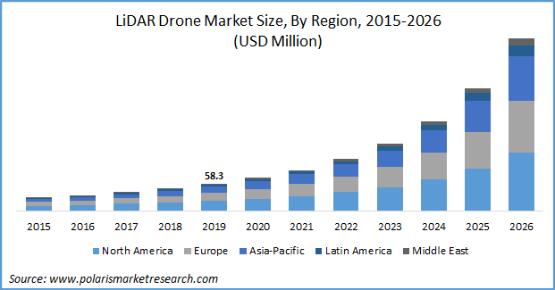
The global LiDAR Drone market size was valued at USD 58.3 million in 2019 and is anticipated to grow at a CAGR of 31.7% during the forecast period. LiDAR drones are increasingly being used for efficient mapping owing to the use of rapid laser pulses for remote sensing. They send out multidirectional laser pulses using oscillating mirrors to map ground points and terrain through analysis of returning pulses. Diverse applications are experiencing an increased demand for high resolution digital surfaces, terrain and elevation models, driving the growth of the market.
Automation of LiDAR drones requires processing systems involving combination of scientific algorithm computation and cloud-based processing of captured data points for sophisticated analysis. The algorithms make them more accurate and efficient in detecting the target objects. The demand of 3D imaging is witnessing rise in consumer, commercial and government applications. LiDAR drones are being adopted in numerous government applications such as planning and monitoring activities related to roadways, railways, cities, and forest management among others The LiDAR captured images are also in demand for corridor mapping in mega infrastructural projects such as airports, railway routes, highways, and water bodies. Application of these drones in smart appliances for sensing purposes would increase the market for short range LiDAR drones.
Know more about this report: request for sample pages
LiDAR drones are being use in the forestry and agriculture sectors for applications such as green netting, estimation of crop health, monitoring of productivity of soil, detection of chemically affected areas, conservation of forests, water resource management and others. They make it easier to capture real-time images of crops remotely exhibiting current status of vegetation for improved data processing, sensitive mapping strategies and analytics of data gathered to determine crop vigor. Growing need for green cover conservation, increased level of pollution and carbon emission in the environment, decrease in the productivity from agriculture industry due to chemicals & pesticide spraying has accelerated the demand for the LiDAR drones.
Increased adoption of cloud computing, GIS, Low-cost LiDAR systems, wireless technologies, advanced motion & temperature sensors, developments in unmanned vehicles, high precision cameras and others would support the growth of this market. High demands for multidimensional models of land structures and topographical maps is also expected to favor the growth of the market. Government and private firms engaged in construction, engineering and mining, surveying, land management and planning are likely to contribute to the increase in demand of LiDAR drones in coming years. LiDAR drones provide safe and precise location-based information useful in excavation and construction as well. The optimization of traffic flow, better route planning and design, detailed topographic models, 3D modelling and reconstruction are some factors leading to the increasing utilization of imagine solutions in civil engineering.
LiDAR Drone Market Report Scope
The market is primarily segmented on the basis of Type, Range, Component, Application and Geographic region.
|
By Type |
By Range |
By Component |
By Application |
By Region |
|
|
|
|
|
Know more about this report: request for sample pages
Type Outlook
On the basis of type, the market is segmented into fixed-wing, and rotary-wing. The demand for rotary-wing drones is expected to be superior than fixed-wing drones during the forecast period. Rotary wing drones are equipped with 2 or 3 rotor blades revolving around a fixed mast. Rotary drones provide the ability for vertical takeoff and landing. These drones are mostly operated in smaller vicinity with limited area. There has been an increasing demand for rotary-wing LiDAR drones across inspection and precision applications owing to its accurate hovering and agile maneuvering capabilities.
Range Outlook
The range segment has been divided into is segmented into Short Range, Medium Range, and Long-Range LiDAR Drones. In 2019, the Short-Range segment accounted for the highest market share. They are widely used in in industrial environments, agriculture and automobile sectors for monitoring in smaller spatial dimensions and rapidly changing low altitude. These drones are used for speedy collection of data points at low cost.
Component Outlook
On the basis of component, the market is segmented into cameras, navigation and positioning units, laser scanners, and others. A massive increase in the use of advanced cameras to capture geographic information of ground data for analysis of geospatial services, GIS, aerial imaging, security and others has been registered. High definition action camera with superior quality of pixel resolution are being developed by market players to cater to the high demands for low cost, automatic aerial solutions with high precision value.
Application Outlook
On the basis of application, the market is segmented into corridor mapping, aerospace and defense, mining, construction, entertainment, environment, agriculture, and others. Corridor mapping accounted for the highest market share in 2019. Corridor mapping finds application in urban planning, flood management, land acquisition, design engineering. Its also used for highway and railway route analysis, infrastructure asset management, airport glide slope hazards to assist in planning and examining preferred routes and their alternatives.
Regional Outlook
North America dominated the global LiDAR Drone Market in 2019. The growth of industrial automation and technological advancements in metrological applications has fueled the adoption of LiDAR drones in North American region. Lidar drones offer improved accuracy, real-time mapping ability and better visualization. LiDAR drones are increasingly being used in the defense sector, which includes geospatial measurement and mapping for military airborne and naval vessels.
Competitive Landscape
The leading players in the LiDAR Drone Market include Geodetics, Inc., Faro Technology, Trimble Navigation Limited, SZ DJI Technology Co. Ltd, Velodyne LiDAR, Inc., Phoenix LiDAR Systems, UMS Skeldar, Teledyne Optech, Riegl Laser Measurement Systems GmbH, YellowScan, OnyxScan, LiDARUSA, Delair, Sick AG, MicroDrones, Leica Geosystems AG, and 3D Robotics, Inc. These companies are taking initiatives to strengthen their market presence by introducing advanced solutions for its customers. These players are also collaborating with other market leaders to expand their offerings and acquire new customers.
License and Pricing
Purchase Report Sections
- Regional analysis
- Segmentation analysis
- Industry outlook
- Competitive landscape
Connect with experts
Suggested Report
- Tokenization Market Share, Size, Trends, Industry Analysis Report, 2022 - 2030
- Global Cancer Pain Management Market Research Report, Size, Share, Trend Analysis and Forecast till 2025
- 3D Machine Vision Market Research Report, Share and Forecast, 2018 – 2026
- Vacuum Evaporators Market Share, Size, Trends, Industry Analysis Report, 2021 - 2028
- Content Disarm and Reconstruction Market Share, Size, Trends, Industry Analysis Report, 2022 - 2030
© 2022 Polaris Market Research and Consulting. All rights reserved